Close burger icon

HELLO THERE, SUPER USER !

Please Insert the correct Name
Please Select the gender
Please Insert the correct Phone Number
Please Insert the correct User ID
show password icon
  • circle icon icon check Contain at least one Uppercase
  • circle icon icon check Contain at least two Numbers
  • circle icon icon check Contain 8 Alphanumeric
Please Insert the correct Email Address
show password icon
Please Insert the correct Email Address

By pressing Register you accept our privacy policy and confirm that you are over 18 years old.

WELCOME SUPER USER

We Have send you an Email to activate your account Please Check your email inbox and spam folder, copy the activation code, then Insert the code here:

Your account has been successfully activated. Please check your profile or go back home

Reset Password

Please choose one of our links :

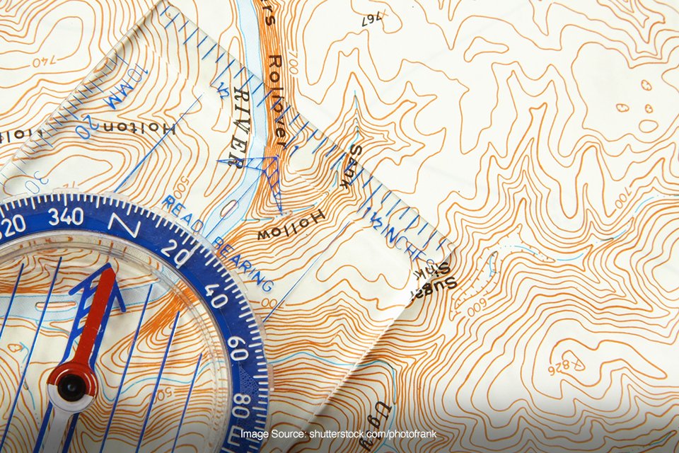
peta topografi

Peta topografi merupakan peta yang menggambarkan relief bumi. Peta ini memiliki fitur-fitur khusus khusus yang ditandai dengan skala besar dan sangat detail. Nah, relief bumi tersebut digambarkan dalam bentuk garis kontur elevasi (ketinggian).

Jadi, lo akan melihat gambaran posisi tegak dan posisi mendatar dari semua objek yang ada di permukaan bumi melalui peta topografi ini. Namun, bagaimana cara membaca peta topografi yang benar? Biar gak penasaran, yuk simak caranya di bawah ini!

Pahami cara membaca garis kontur terlebih dahulu

Image source: shutterstock.com/gubernat

Jika Superfriends ingin mengetahui lokasi, jarak, serta rute perjalanan melalui peta topografi harus memahami cara membaca garis-garis kontur terlebih dahulu. Garis kontur merupakan komponen utama yang ada pada peta topografi. Garis tersebut dapat menunjukkan tinggi rendahnya suatu permukaan sesuai dengan skala tertentu.

Cara membaca peta topografi untuk mengetahui ketinggian suatu wilayah, yaitu dengan mengamati titik ketinggian yang ada di peta melalui garis konturnya. Informasi ketinggian juga dapat diketahui dengan melihat notasi ketinggian pada garis kontur dalam peta topografi.

Amati kerapatan garis kontur yang ada di peta

Image source: shutterstock.com/Sergei Drozd

Selain itu, cara membaca peta topografi untuk mengetahui bentuk lahan bisa dilakukan dengan mengamati kerapatan garis kontur di peta. Garis kontur yang rapat menandakan bahwa garis kemiringan dari permukaan di wilayah tersebut semakin terjal.

Sedangkan, garis kontur yang renggang menunjukkan bahwa permukaan di suatu wilayah cukup landai atau datar. Jika ditelaah dan dicoba, sebenarnya cukup mudah untuk membaca peta topografi karena hanya berpusat pada garis kontur di dalamnya.

ARTICLE TERKINI

Author : Admin Adventure

Article Date : 11/02/2023

Article Category : News

Tags:

#Beginner #Urban Action #Tips #Extreme

Source:https://blog.eigeradventure.com/cara-membaca-peta-topografi/

0 Comments

Comment
Other Related Article
image article
News

5 Spot Sunrise Bali Terbaik, dari Gunung Hingga Pantai

Read to Get 5 Points
image arrow
image article
News

Curug Leuwi Hejo Bogor: Panduan Harga, Rute dan Jam Buka

Read to Get 5 Points
image arrow
image article
News

Mau ke Gunung Sangar? Simak Dulu Harga Tiket dan Jam Bukanya!

Read to Get 5 Points
image arrow
image article
News

5 Teluk Terindah di Indonesia yang Wajib Masuk Daftar Liburan

Read to Get 5 Points
image arrow
image article
News

Jaket Gorpcore Terbaik untuk Hiking dan Pecinta Alam

Read to Get 5 Points
image arrow
image article
News

Mengapa Aluminium Foil Wajib Dibawa Pendaki? Ini Jawabannya!

Read to Get 5 Points
image arrow
image article
News

5 Spot Diving di Nusa Penida dengan View Paling Menawan

Read to Get 5 Points
image arrow
image article
News

5 Spot Surfing Pantai Pangandaran yang Siap Memanjakan Adrenalin

Read to Get 5 Points
image arrow
image article
News

Upas Hill: Surga Pendaki Budget Friendly, Rute Mana yang Lo Pilih?

Read to Get 5 Points
image arrow
image article
News

Hidden Gem Air Terjun Semuncar: Tiket, Rute, dan Jam Operasional

Read to Get 5 Points
image arrow
1 /

Daftar dan Dapatkan Point Reward dari Superlive